
Product Center
-
Hydrological equipment monitoring station
-
Water Quality Monitor Sensor
-
Plant protection equipment
-
Food Testing Equipment
- How does Multi Depth Soil Moisture Probe achieve simultaneous measurement of soil temperature and humidity at multiple depths?
- The standard buoy five-parameter monitoring system enables automatic water quality data acquisition and remote transmission
- How the Tubular Soil Temperature and Moisture Monitor Achieves Simultaneous Multi-Layer Soil Parameter Measurement
- IoT Water Quality Monitoring Station enables the automatic acquisition and remote transmission of in-situ water quality monitoring data
- Soil Moisture Monitoring Enables Simultaneous Measurement of Soil Temperature and Moisture at Multiple Depths
- The high-spec buoy with five parameters enables more accurate lake water quality monitoring
Shandong Fengtu IOT Technology Co., Ltd
Sales Manager:Ms. Emily Wang
Tel, Whatsapp:+86 15898932201
Email:info@fengtutec.com
Add:No. 155 Optoelectronic Industry Accelerator, Gaoxin District, Weifang, Shandong, China
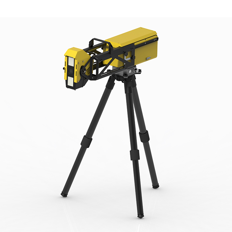
Slope Monitoring Radar
Model:FT-BPLD2
Brand:fengtu
 Get a Free Quote
Related products
Product details
1、Slope Monitoring Radar Product Overview
Slope Monitoring Radar employs a non-contact, safe monitoring method to conduct continuous, all-weather deformation monitoring of large-scale, multi-level slopes.The BPLD2 emergency portable 360° Slope Monitoring Radar is based on the proprietary arc-shaped synthetic aperture radar system and phase differential interferometry technology developed by Sun Yat-sen University. It enables non-contact, continuous, and high-precision remote sensing monitoring and timely early warning of slopes, dams, mountains, and buildings at landslide rescue sites, eliminating the safety threats posed by secondary disasters to rescue personnel and equipment.
Slope Monitoring Radar adopts an edge computing architecture, with information processing, positioning, and wireless communication functions all integrated within the device. Weighing less than 10 kg and with a maximum folded size of less than 50 cm, it can be easily carried as baggage or deployed by a single person, allowing for rapid deployment and monitoring by emergency rescue teams at disaster sites. It features 360° wide-range coverage, 0.1mm precision measurement, all-day and all-weather operation, and resistance to harsh environments such as clouds, rain, fog, snow, dust, and fire. It is also specially designed for emergency and rapid response needs, with a lightweight, portable, and low-power design, making it industry-leading in weight, size, power consumption, and portability.
2、Slope Monitoring Radar Application Areas
Landslide Rescue Emergency Monitoring
Mine Side Landslide Emergency Rescue Monitoring
Building Collapse Monitoring (Instability & Fire & Ice Disaster)
Dam Failure Monitoring
3、Slope Monitoring Radar Product Features
Emergency-Specific Version: Specially customized for emergency scenarios
Strong microwave penetration, providing all-weather, 24/7 monitoring capability, unaffected by rain, snow, fog, smoke, dust, or fire.
No Protective Installation Required: Unaffected by outdoor wind, sun, rain, dust, or heavy snow; no monitoring room required.
Adaptive Atmospheric Disturbance Compensation Algorithm
Utilizing circular arc imaging and continuous wave radar, it can monitor 360° all angles, with no blind spots due to angle or distance.
24/7: Continuous scanning
3D Fusion: Sub-meter level registration
All-weather, full-area monitoring
Automatic judgment, automatic early warning, unattended operation
IP65 protection, for emergency use, normal operation at -40℃
Ultra-light and portable, weighing only 10kg, can be carried by one person by hand/on their back for quick access to the rescue site. When folded, its dimensions are only 0.5×0.35×0.25m, which can be placed in a 24-inch storage and transport case, meeting the requirements for onboard baggage handling in civil aviation.
4、Slope Monitoring Radar Key Performance Indicators of Radar and Platform Software
1) Maximum Detection Range: ≥5000m
2) Deformation Accuracy: ≤0.1mm (all azimuth angles)
3) Coverage Area: ≥360°×35°
4) ★Electrically Controlled Pitch Adjustment Angle: ±40° (Electrically controlled, manual adjustment by default)
5) Range Resolution: ≤0.3m
6) Azimuth Resolution: ≤8mrad
7) Acquisition Cycle: Adjustable from 0.5 to 4min
8) Radar Power Consumption: ≤45W
9) ★Radar Weight: ≤10kg, supports tripod mounting
10) ★Supports extendable/retractable configuration for storage Maximum dimensions in state: ≤0.5m
11) ★ Maximum dimensions of packaging box: ≤0.7m
12) Transportability: Can be carried by a single person, can be checked in with flights or high-speed trains.
13) Operating temperature: -40°C~55°C (optional, default -20°C)
14) Protection rating: ≥IP65
15) ★ Radar main unit has a built-in satellite compass, supporting autonomous positioning and orientation (optional)
16) Radar main unit has built-in 4G wireless (optional) and wired communication functions.
17) The main unit uses edge computing, completing all processing internally, eliminating the need for external processing equipment.
18) Deformation drift after atmospheric calibration ≤±1 0.5mm (1000m, 48h)
19) The radar must be domestically developed and manufactured equipment.
20) (Early Warning Software) Supports deployment on physical servers or cloud servers; allows remote device restart; the software adopts a B/S architecture, supporting simultaneous access by multiple users.
21) (Early Warning Software) Supports thematic layer selection and quantitative analysis of feature points or regions, generating curves and reports.
22) ★ (Early Warning Software) Possesses air-varying atmospheric phase correction function; can display deformation maps within a specified time range.
23) (Early Warning Software) Data fusion: Supports UAV modeling, CAD 3D modeling, and laser 3D point cloud modeling data. Fusion with radar data;
24) (Early Warning Software) Features a large-screen monitoring mode; the software interface uses Chinese language; supports curve continuation function;
25) (Early Warning Software) Has 360° imaging capability;
26) ★ (Early Warning Software) Offers free data interface to the client;
27) ★ Supports deformation/rate graded heat map;
28) (Early Warning Software) Supports 4-level automatic judgment and early warning, supports audible, visual, and SMS alarms;
29) ★ (Early Warning Software) Supports generating Word format reports for specified time periods;
30) (Early Warning Software) Allows setting early warning shielding zones to effectively shield false alarms in the work area.
This paper addresses:https://fengtusz.com/Slope-Stability-Radar/Slope-Monitoring-Radar.html
- Previous Article :Slope Stability Monitoring Radar
- Next Article:no more
Related article
-
Handheld Depth Finder FT - CS150: Mastering Water Depth Detection with Ease
2025-02-10 -
Multi-parameter water quality analyzer enables simultaneous online monitoring of residual chlorine, turbidity, pH, and conductivity
2026-06-03 -
Introduction to Soil Moisture Monitoring System
2025-01-06 -
Core Monitoring Equipment (Magnetostrictive Weir Gauge, GNSS Station) and Manufacturer for Reservoir Dam Safety
2025-08-21 -
Earth-Rock Dam Safety: Design of Surface Displacement Monitoring System
2025-07-10 -
Reservoir Level and Flow Monitoring System Helps Flood Control and Drought Relief
2024-05-29 -
soil moisture monitoring station Supports Three Transmission Modes: Wired, GPRS, and Bluetooth
2026-04-30 -
Soil profile moisture meter can measure soil profile moisture, temperature, and electrical conductivity
2025-12-16