
Product Center
-
Hydrological equipment monitoring station
-
Water Quality Monitor Sensor
-
Plant protection equipment
-
Food Testing Equipment
- IoT Water Quality Monitoring Station enables the automatic acquisition and remote transmission of in-situ water quality monitoring data
- Soil Moisture Monitoring Enables Simultaneous Measurement of Soil Temperature and Moisture at Multiple Depths
- The high-spec buoy with five parameters enables more accurate lake water quality monitoring
- Advantages and Application Scenarios of Non-Contact Measurement Technology for Radar Water Level Monitoring Equipment
- Which brand of water quality testing equipment is the best? Shandong Fengtu wins market recognition with its high precision and low price
- Measurement Accuracy of Three-Parameter Soil Monitors and Their Application in Smart Agriculture
Shandong Fengtu IOT Technology Co., Ltd
Sales Manager:Ms. Emily Wang
Tel, Whatsapp:+86 15898932201
Email:info@fengtutec.com
Add:No. 155 Optoelectronic Industry Accelerator, Gaoxin District, Weifang, Shandong, China
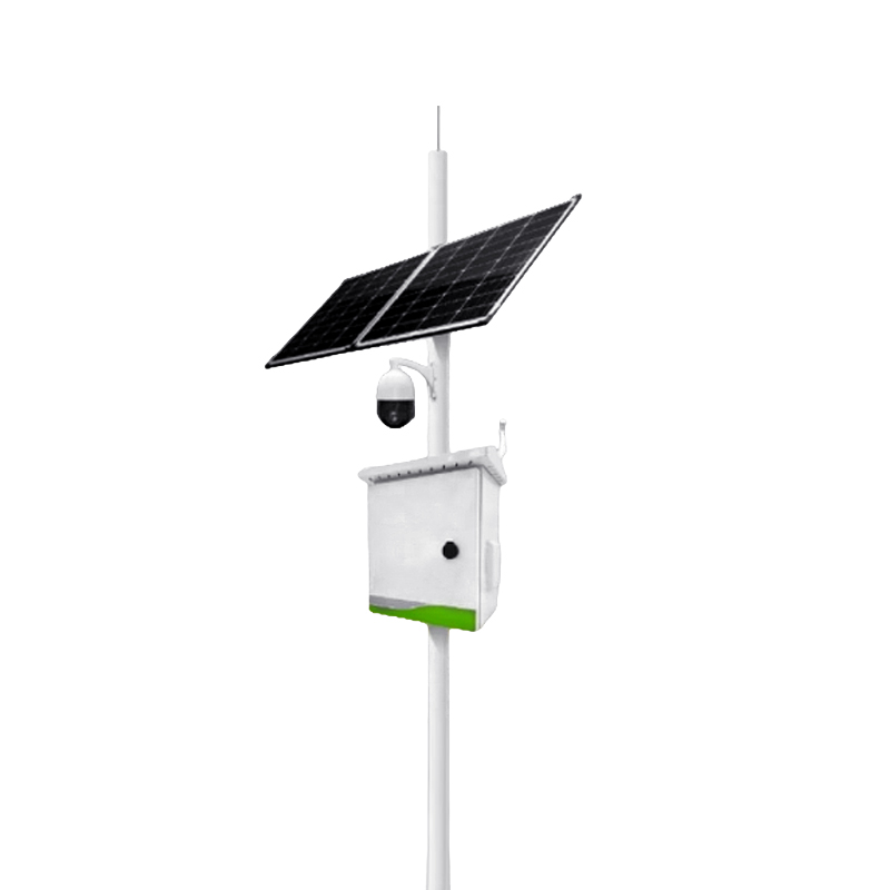
Animal monitoring device for embankments
Model:FT-BY4
Brand:fengtu
 Get a Free Quote
Related products

Product details
1、Animal monitoring device for embankments Product Applications
Common burrowing animals that damage water conservancy dams and embankments include badgers, foxes, and rats. Because these animals are typically found in areas with dense vegetation, and due to their natural needs for nesting, foraging, or avoiding predators, earthen dams often become frequent activity areas for wildlife. These animals dig burrows, feed, inhabit, and travel across the dam structures.These animal activities cause a series of problems for earthen dams; their burrows compromise the integrity of the embankment, weaken its flood resistance, and can even lead to dam failure.Therefore, this intelligent AI monitoring system for dam-damaging animals can effectively identify and deter these animals, preventing them from nesting and engaging in other destructive behaviors on critical dam projects.
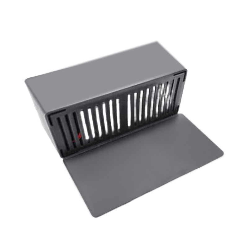
2、Animal monitoring device for embankments Product Features:
1.Infrared thermal imaging camera accurately identifies heat sources of burrowing animals, avoiding false triggers.
2.AI visual intelligent recognition processes data using target detection algorithms for precise identification and intelligent control.
3.AI local deployment improves data security and reduces network dependency, allowing for normal operation even offline.
4.Independently developed embedded board based on the latest domestic AI recognition chip offers superior performance and stable supply.
5.Distributed deployment allows for the installation of wireless deterrents along the desired dispersal path.
6.Wireless deterrents: 6-channel ultrasonic dispersal, 360-degree coverage, range 0-10m.
7.Customizable communication protocols support hydrological standards and meet the data security requirements of water conservancy monitoring platforms.
3、Animal monitoring device for embankments Technical Principles
Utilizing intelligent AI recognition technology, the system triggers wireless deterrents via a smart gateway. It employs a dual technology approach combining ultrasound and infrared thermal imaging.When a pest animal enters the detection range, the AI camera immediately captures its body temperature and movement signals, automatically triggering a high-frequency ultrasonic mode.This non-contact method is imperceptible to humans but effectively disrupts the animal's auditory and visual systems, causing them to instinctively avoid the area, thus providing long-term protection.
4、Animal monitoring device for embankments Technical Specifications
Intelligent Recognition Terminal:
1.Power supply: 12.6V/2A, power consumption: 5W.
2.2-megapixel infrared thermal imaging camera.
3.Solar powered/DC 12.6V.
Wireless Dispersal Device:
1.Power supply: 5V/0.2A, power consumption: 0.5W.
2.Solar powered/Battery.
5、Animal monitoring device for embankments Software Introduction
The visual cloud platform, based on satellite GIS imagery maps, displays the location and status of monitoring points, and shows monitoring statistics and today's alarm list.Monitoring point status is divided into normal and alarm; normal monitoring points are green, and alarm monitoring points are red.Monitoring statistics include monitoring point statistics, equipment status statistics, and termite infestation alarm statistics.The today's alarm list displays all alarm records for the day.
Hovering over a monitoring point icon displays a small pop-up window showing the monitoring point name, termite infestation status and latest monitoring value, equipment voltage status and latest monitoring value, and the latest monitoring value of the temperature inside the box.
Clicking on a monitoring point icon displays the monitoring point name, supports quick and custom queries, and allows switching between monitoring elements.
1.The termite visualization cloud platform is compatible with both PC and mobile app versions;
2.Supports termite monitoring equipment management for various application scenarios such as water conservancy dams, river embankments, landscaping, building construction, cultural heritage buildings, and irrigation canals;
3.Features data management and real-time termite invasion early warning functions for the latest AI visual recognition equipment, and remote pest control functions;
4.The visualization platform features GIS map annotation of monitoring points, monitoring trend graph display, and equipment status (with termites, without termites, offline, etc.);
5.Provides termite control work order management, including issuing inspection work orders, and uploading on-site equipment photos and videos;
6.Includes statistical functions for reservoirs, embankment surveys, and termite damage levels, with reporting and verification mechanisms for different management permissions;
7.Provides functions for querying, modifying, statistically analyzing, archiving, and exporting monitoring information and control and maintenance records;
8.Displays the real-time status of monitoring points (e.g., no termites, termites present,
in the process of extermination, exterminated, online, offline, damaged, battery level, temperature and humidity, etc.) and coordinate display;
9.Termite infestation triggers support software platform warnings, mobile app linkage warnings, and SMS warnings;
10.The visualization platform provides batch control functions for mobile alarms and parameter settings of termite monitoring equipment.
This paper addresses:https://fengtusz.com/Termite-monitor/Animal-monitoring-device-for-embankments.html
- Previous Article :Termite Monitoring and Control System
- Next Article:no more
Related article
-
Soil moisture monitor can test photovoltaic strings up to 30kW
2026-05-29 -
Soil Moisture Sensors: Types, Technology and Selection Guide
2025-10-17 -
Soil moisture temperature salinity PH tester: A Handy Tool for Comprehensive Soil Parameter Measurement
2025-04-14 -
Revolutionizing Water Quality Monitoring: From Traditional to Advanced Sensors
2024-11-15 -
Predicting Flooding Trends with Water Early Warning Systems
2024-03-04 -
Forest weather stations fire warning to be done
2024-04-25 -
Irrigation flow monitoring system, high standard farmland irrigation water management
2024-05-08 -
Which Brand of Water Quality Testing Instruments Is Best? We Recommend Fengtu Technology
2026-04-13