
Product Center
-
Hydrological equipment monitoring station
-
Water Quality Monitor Sensor
-
Plant protection equipment
-
Food Testing Equipment
- Measurement Accuracy of Three-Parameter Soil Monitors and Their Application in Smart Agriculture
- A fluorescence-based dissolved oxygen sensor achieves maintenance-free dissolved oxygen monitoring using optical measurement principles
- Rodent Monitoring Device: Automated Capture, Identification, and Reporting via One-Way Passage and HD Camera
- Floating island-type solar-powered water quality monitoring equipment can be deployed and installed without hoisting
- Soil Moisture Monitoring Equipment Eliminates Experience-Based Irrigation Decisions
- The water level detector utilizes K-band planar radar technology to achieve non-contact, high-precision water level measurement
Shandong Fengtu IOT Technology Co., Ltd
Sales Manager:Ms. Emily Wang
Tel, Whatsapp:+86 15898932201
Email:info@fengtutec.com
Add:No. 155 Optoelectronic Industry Accelerator, Gaoxin District, Weifang, Shandong, China
River level measurement
Model:FT-SW1
Brand:fengtu
 Get a Free Quote
Related products
Product details
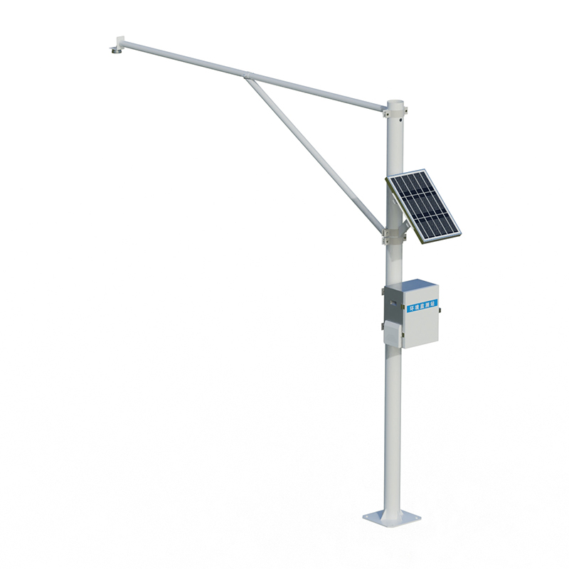
1.River level measurement product overview
River level measurement is mainly used to collect water level data of reservoirs, lakes and rivers, and monitor rainfall through changes in river level to reduce flood disasters.SW1 is a fully automatic hydrological online monitoring system based on microwave technology, which can measure water levels in channels simultaneously.It uses advanced K-band plane radar technology to measure the water level of water bodies through non-contact methods, and calculate and output real-time water level data according to built-in software algorithms; it can be used for non-contact flow measurement in rivers, irrigation canals, underground drainage pipelines, flood prevention warnings and other occasions; the product has the characteristics of low power consumption, small size, high reliability and convenient maintenance; the measurement process is not affected by factors such as temperature, silt, river pollutants, and floating objects on the water surface.
2.River level measurement Application Field
1.Water level measurements for rivers, lakes, tides, reservoir gates, groundwater pipelines, irrigation channels, etc.
2.Auxiliary water treatment operations, such as urban water supply, sewage discharge monitoring, etc.
3.Flow calculation, inlet and drainage flow monitoring, etc.
3.River level measurement product features
1.Non-contact measurement, calculate flow in combination with cross-sectional parameters, and is not affected by wind, temperature, haze, silt, sand, floating objects, etc.
2.It is suitable for a variety of measurement conditions, and is not affected by corrosion and foam, and can output water level measurement data.
3.The water level uses a planar array radar antenna, with its own angle measurement function, the equipment is small in size and easy to install.
4.Convenient configuration software can easily configure parameters according to actual needs to adapt to different usage conditions.
5.Not affected by changes in water vapor, temperature and pressure in the atmosphere
4.River level measurement Monitoring Platform
1.CS architecture software platform, supports direct observation of mobile phones and PC browsers without additional software installation.
2.Support multiple accounts and multiple devices to log in
3.Support real-time data display and historical data display dashboard
4.Cloud server and cloud data storage are stable and reliable, easy to scale, and load balancing.
5.Support SMS alarm and threshold settings
6.Support map display and viewing device information.
7.Support data curve analysis
8.Support data export table form
9.Supports data forwarding, HJ-212 protocol, TCP forwarding, http protocol, etc.
10.Support data post-processing function
11.Support external running of javascript scripts
5.River level measurement Summary Indicators
Supply voltage: 100mA (operation), <1mA (sleep);
Working voltage: 12V power supply
Operating temperature: -35℃~60℃;
Storage temperature: -40℃~60℃;
Field protection level: IP68
Signal output: RS485/MODBUS protocol;
6.River level measurement Technical Parameters
Water level measurement
Range measuring range: 0.1-40 meters
Range measurement accuracy: ±5mm
Range measurement resolution: 1mm
Interval time: 1-5000min
Power supply method: combined power supply of solar panels + battery
Solar power: 10W/30W (optional)
Battery parameters: DC3.7V 10Ah
Support height: vertical pole 3 meters cross arm 3 meters
Working environment: -45℃~85℃ (not freezing state)
7.Precautions for installing River level measurement
1.Installation environment
There are no huge stones in the test channel blocking the water, no huge vortexes, turbulences, etc.
The test channel section should be straight, stable, and concentrated
The test channel section needs to be hardened, and the measurement section should be regular
The test channel section should be kept smooth to prevent floating objects from accumulating
2.Installation height
Recommended installation height 3-4 meters
This paper addresses:https://fengtusz.com/Water-Level-Monitoring-System/River-level-measurement.html
- Previous Article :no more
- Next Article:Rainfall Monitoring
Related article
-
FT - LF2 Crack Monitor: Your Shield Against Geological Risks
2025-01-21 -
School weather station: A Valuable Educational Tool in School
2024-11-18 -
An Introduction to Propeller Flow Meter and Its Working Mechanism
2024-12-17 -
Water Quality Monitoring: Dissolved Oxygen and the Role of FT - SS04 Portable Water Quality Meter
2025-02-12 -
Wireless Soil Moisture Monitor: Real-Time Remote Environmental Monitoring
2025-10-10 -
Online Ammonia - Nitrogen Sensors: Pivotal Tools in Understanding, Measuring and Solving Ammonia - Nitrogen Issues
2025-02-18 -
The Significance of Water Quality Monitoring in River Restoration Projects
2025-01-15 -
The Significance and Function of Handheld Weather meter in the Wild
2025-03-17