In the field of ecological environment, soil erosion is an important issue that has attracted much attention.
It refers to the situation where, under the influence of natural or human factors, the water flow formed by rainfall cannot be fully absorbed and retained by the ground surface. As the water flows along the terrain, it scours the soil, resulting in the simultaneous loss of soil and water.
In terms of topography and geomorphology, in areas with a steep slope, the water flow is fast and has a strong impact force during rainfall, making it easy for soil particles to be washed away. Regarding rainfall characteristics, short - term and high - intensity rainfall creates a strong surface runoff because the rainwater has no time to infiltrate, greatly increasing the risk of soil erosion. Vegetation coverage is also crucial. In areas with low vegetation coverage, the soil lacks the fixation of plant roots and the obstruction of surface vegetation, making it more vulnerable to being scoured by rainwater.
Unreasonable land reclamation, such as reclamation on steep slopes, destroys the original vegetation and soil structure, leaving the soil directly exposed to rainwater scouring. Excessive deforestation reduces the interception of rainwater by forests and the protection of the soil. In engineering construction, if effective soil and water conservation measures are not taken, activities such as open - pit mining and road construction will disturb a large amount of surface soil, creating conditions for soil erosion.
Monitoring can help us keep track of ecological environment changes in real - time. Once an exacerbation of soil erosion is detected, measures such as afforestation and slope protection by planting grass can be taken in a timely manner to restore vegetation, enhance the soil's anti - erosion ability, maintain ecological balance, and avoid the degradation of the ecosystem.
In the work of soil erosion monitoring, data from multiple aspects need to be paid attention to. The amount of soil erosion is a key indicator for measuring the degree of soil erosion. By setting up observation points in specific areas and using methods such as on - site measurement and sampling analysis, it can be obtained, which directly reflects the severity of soil erosion.
The change in topography and geomorphology is also an important monitoring content. Using topographic survey and remote sensing monitoring methods, changes in slope gradients and gully densities on hillsides are regularly monitored. These changes are closely related to soil erosion. For example, as soil erosion intensifies, the slope gradient of the hillside may become gentler due to soil erosion, and the gully density may increase.
Vegetation coverage is an important reference for evaluating the situation of soil erosion. Through ground surveys combined with satellite remote sensing monitoring, the proportion of vegetation - covered area in the monitored area is accurately calculated. Vegetation plays a significant role in soil and water conservation, and changes in its coverage directly reflect the effectiveness of soil erosion prevention and control and the changing trend of the ecological environment.
Monitoring of runoff and sediment concentration is essential. Monitoring sections are set up in rivers and streams, and flow - measuring instruments and sediment - sampling equipment are used to accurately measure the surface runoff volume and sediment concentration in the water flow, directly reflecting the loss of water and soil during the soil erosion process and providing an important basis for analyzing the laws of soil erosion.
Meteorological data such as rainfall, rainfall intensity, and wind speed are important driving forces for soil erosion. Real - time monitoring through meteorological stations and comprehensive analysis combined with other monitoring data can help us understand the causes and mechanisms of soil erosion and provide a scientific basis for formulating prevention and control measures.
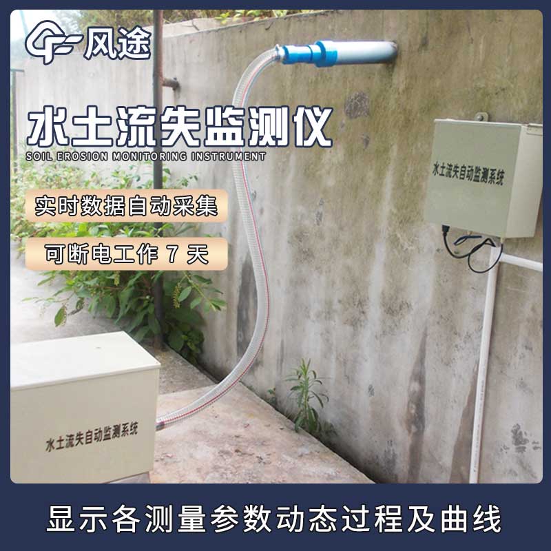
FT - LS1 Soil Erosion Monitoring, launched by Fengtu, is specifically designed for precise soil erosion monitoring.
This device works with the coordination of multiple components. The data - acquisition, storage, and main control unit manages data management, storage, and remote transmission. The sediment - concentration measurement sensor monitors the sediment concentration in runoff in real - time. The surface - flow sensor assembly automatically measures the surface runoff. The rain - gauge sensor focuses on measuring rainfall - related data.
It can operate unattended around the clock and automatically measure and store key data. It is powered by solar energy, goes into hibernation when there is no rainfall or runoff, and can still work for 7 days in case of power failure. The data processing is flexible, supporting local storage, interface download, and wireless transmission. It can also perform real - time monitoring and chart drawing.
In terms of technical indicators, it is accurate in measuring flow, sediment concentration, and rainfall, and performs excellently in communication, power supply, power, temperature, and service life, providing a solid guarantee for soil erosion monitoring work and serving as an important force in protecting the ecology.

This paper addresses:https://fengtusz.com/industry/641.html


